Clean & transform location data into geospatial time series.
Geofilter accepts location data via FTP file uploads or HTTP requests. GIS functions clean, transform and aggregate the data into streams of geo time series, trip segments, route maps and address elements.

Uses
Vehicle Tracking - IoT
GPS devices used for vehicle tracking are susceptible to errors caused by signal reflections from buildings, system clock errors and static navigation-jumps when stationary. Geofilter can accept high volume data from GPS devices and smoothen it by removing outliers. Auto trip detection and address geocoding produce clean trip segments and route maps. We built Geofilter using our experience in building fleet tracking systems for OBDII GPS trackers manufactured by Teltonika and Queclink.
Mobile Apps
Apps with geolocation tracking can use Geofilter to clean and enrich data. React Native Background Geolocation by TransistorSoft is a popular, battery conscious location tracking SDK for Android and IOS. Geofilter has inbuilt support for the file formats produced by the SDK. You can directly send data from mobile apps to Geofilter instance.

Mapping & Visualisation
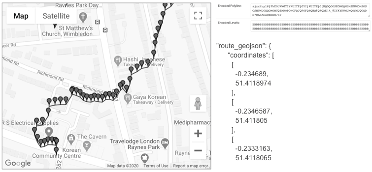
Auto trip detection feature identifies trips or journey segments in the location data. Geofilter produces GeoJSON LineStrings and Google Polylines representing routes. You can use GeoJSON and polylines for mapping and visualising routes on Google Maps, Leaflet mapping library etc.
Batch geocoding
Match every data point to the nearest OpenStreetMap address. Geofilter can reverse geocode any volume of records with worldwide OpenStreetMap address coverage. Throughput is limited only by the capabilities of AWS server instance type you choose.
One click GIS backend
We built Geofilter on Postgres PostGIS open-source tech stack. You can spin up a GIS backend in minutes when prototyping or building an MVP. We use it in production as a backend for web and mobile apps. Mobile apps or GPS devices send data to Geofilter instance. We then use API methods to pull data into the Firebase backend used by our mobile and web apps.
Features
Stream processor
Receive location via HTTP post. Flexible data schema.
File processor
Receive location data via file uploads. Accepts fixed width, delimited or JSON data. Write declarative file format specification to process your custom format files.
Filter: Clock skew
Timing error indicates GPS fix issues. Usually reported location is also wrong in such cases.
Filter: Accuracy
Filter out records below defined accuracy thresholds. This filter uses accuracy indicators reported by GPS devices.
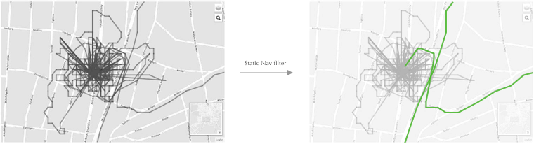
Filter: Static navigation
Static navigation is the drift in locations recorded by a stationary GPS device. Multi-path signals reflected off nearby objects can cause such errors. When visualised you see spikes around the actual coordinates.
A static navigation example from StackOverflow:
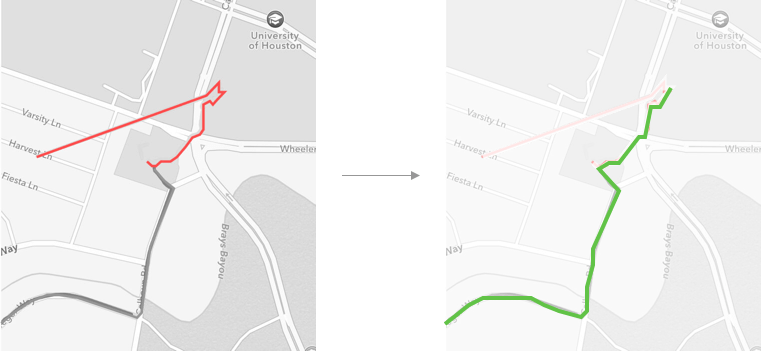
Filter: Location jumps
Similar to static navigation drifts. Location data has random spikes or jumps when moving. Multi-path reflected signals from tall buildings or partial signal loss from some satellites can cause location jumps.
An example from StackOverflow:
Support for React Native Background Geolocation (Rnbg) library data format
Configure Rnbg mobile SDK to POST location data instantly or in batches. Geofilter API has native methods to receive, parse and transform Rnbg data in single or batch mode.
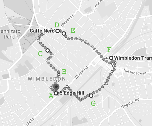
Auto trip detection
Segment location data into trips or journeys with start-end times and addresses, trip distance and route map.
Address reverse geocoding
Fast reverse geocoding. Match every data point to the nearest OpenStreetMap address. Geofilter can reverse geocode any volume of records with worldwide OpenStreetMap address coverage. Throughput is limited only by the capabilities of AWS server instance type you choose.
Route mapping
Geofilter produces GeoJSON LineStrings and Google Polylines representing routes. You can use GeoJSON and polylines for mapping and visualising routes on Google Maps, Leaflet mapping library etc.
Support
You can find examples in the Documentation.
If you have any questions, contact Anu Joy or use the links below.
I work in projects involving python, data, gis, low cost green technical architecture design, IoT, tech content-driven marketing and SEO.
Contact us for help with any R&D or road mapping challenges you have.